All pictures on this page can be clicked to see a larger (900x600) image.
Please note that the pictures and text on this page will display differently in different browsers, based on your own computer's settings.
If you have any questions, or just a comment about this report, please feel free to Click Here to send a comment to the Webmaster (Kevin). Your comments are always appreciated!
DAY 1 - Thursday, June 9, 2005
Sometime in February of 2005, I told my wife that one of my oldest friends (Damian) and myself were planning on a trip to Helper, Utah sometime around Memorial Day. When June 9 came along, she was behind me 100%, telling me to have a wonderful time. This trip is dedicated to her (as well as my two year old daughter) for always supporting my hobby (or, obsession even) with trains and photography.
On Thursday, June 9, 2005, Damian and I left Denver, CO westbound on I-70, heading for the western end of the Denver and Rio Grande Western. This was the sixth such road trip for us, and it was by far the best trip we've had thus far. The previous five trips, we have concentrated on Soldier Summit. The drive out and back was direct, making very few stops along the way. Time was primarily spent between Price, UT and Provo, UT. As time has gone on (and as we have become more familiar with Soldier Summit), there has been a growing urge to spend more time in the desert. We decided this year would be the year.
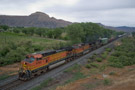
We left the Denver-Metro area shortly after noon and made it to Grand Junction shortly after 4:30pm and starting looking for the first thing to chase, hopefully west into the desert. The first thing we came across was the MRONY-09, getting ready to leave Grand Junction after a crew change. DS-80 informed UP 4371 that they would be headed 13 miles east to the siding of Palisade where they would be holding for awhile. We following the train to the east end of Palisade where the train held, waiting for maintenance and Amtrak 5 (the westbound California Zephyr).
The weather was not looking like it was going to be very cooperative. We decided to head back to the west end of the yard in Grand Junction to see if we could find anything moving while waiting for Amtrak to arrive. A quick check on the weather indicated that it would be hit and miss for the entire trip. If we were lucky, it would be clear. If we were unlucky, it would be overcast with "drizzle".
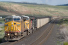
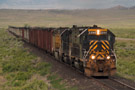
When we got back to Grand Junction and parked along South Avenue near 5th Street. A short hike up the bridge on 5th Street (also US-50) offered a nice view of the tracks to the east. We heard DS-80 issue a track warrant to SP 173 (an empty coal train) that was ready to leave the yard for the North Fork branch, heading for Bowie Mine. The train received a track warrant from MP 1.0 to Roubideau, nearly fifty miles away.
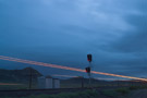
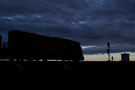
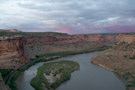
Amtrak arrived in Grand Junction late (largely due to a rock slide in Byers Canyon a day earlier). Amtrak entered the depot siding at 7:45pm. We had decided that we were going to camp our first night in Ruby Canyon. We weren't sure if we would have time, but we decided to try to make it to the canyon ahead of Amtrak and shoot running through the base of the massive gorge.
Ruby Canyon can be accessed from I-70 by taking the Rabbit Valley exit (Exit 2) in western Colorado. While the drive to the canyon is not a bad one in a 4x4, I would not recommend entering the trails in any vehicle other than one designed for off roading! The drive in from the highway took 20 to 25 minutes and, when we stopped, we jumped out of the truck and headed for the canyon edge (about 150 feet away from the parking area). As we were heading for the edge, we heard the distinct sound of Genesis P42s deep in the canyon below. Before reaching the edge, sure enough, "Amtrak 5, highball Utaline" came across the scanner.
Feeling a little disheartened by the less-than-perfect weather and the lack of trains, we grabbed a few pictures of the sun setting around 9pm before preparing to call it a night. Sleeping in the six foot bed of a S10 ZR2 when you are six feet tall is not exactly comfortable! With the tailgate down, I can comfortably (well, reasonably comfortably) stretch out and fall asleep. So, of course, the rain came around 11pm just as we were preparing to turn in for the night. With the tailgate closed, I struggled to get as comfy as I could in my down sleeping bag, getting five hours of sleep if I was lucky.
DAY 2 - Friday, June 10, 2005
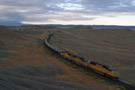
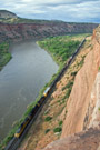
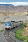
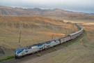
When we woke up at 6:15am Friday morning, the rain had stopped, but the sky was still overcast and it looked like the rain might return at any moment. However, within ten minutes of getting up, we heard the scanner chime in with the eastbound MRONY-09 heading our way. After preparing for the day (pants and a sweat shirt in June!), we headed back down to the ledge we had found the night before and waited for the train to highball Utaline. At 7:10am, the sun peaked out from behind the clouds in the eastern sky, lighting up the canyon. Five minutes later, the eastbound rounded the curve from the east end of Utaline and into view.
The MNYRO/MRONY, ever since being re-instated in April 2005, has typically been handled under the care of three or four SD70M's. This Friday morning was no exception as three SD70M's led a 40-car manifest train through the canyon. The trains horn echoed off of the canyon walls as it approached McDonald Creek, giving some campers on the opposite shore a nice wake up call! It was shortly thereafter that I heard Damian shout "nooooo" from behind me. I turned around to see him leaning over the edge of the canyon. I asked "what happened!?" hoping to see his camera still in his hand. Fortunately, it was just a lens cap. It slipped out of his pocket and he watched it roll to the edge and drop off into the great abyss below!
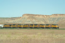
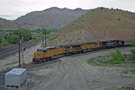
Once the train had passed, we hung out for a few minutes listening to the scanner, hoping to hear some indication that the Potash Local (scheduled to run west to Brendel and south on the Cane Creek Sub on Friday's). With nothing (apparently) headed west out of Grand Junction, we broke camp and headed back to I-70. By the time we reached Fruita, we were very hungry and needed gas. We stop so everyone could refuel. By the time we reached Grand Junction, the rain had started again. This was not looking very good! We got back to the yard around 9:15am and found the Potash Local sitting on an outbound track near the west end of the yard. Unfortunately, there was no crew in site. The local had two Espee (well, one was technically patched UP now, with an interested patch job of two UP shields on the nose) AC4400CW's for power.
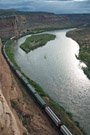
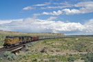
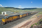
Shortly thereafter, we heard the westbound BNSF Denver to Stockton trackage rights train was approaching Grand Junction. This was wonderful news as we knew this train would be headed west across the desert. Things were starting to look up. We headed east to Clifton to await the arrival of the Denver-Stockton, which was currently approaching Palisade. The rain had stopped, but the clouds remained. As the Denver-Stockton approached from the east, we heard on the scanner that UP 6193 was just departing Grand Junction. After review our notes, we realized that UP 6193 was indeed the Potash Local. The train had to stop at Fruita momentarily to drop off three ballast cars before continuing west to Brendel. The Denver-Stockton passed underneath us as we stood on the US-6 overpass just east of the east switch of Clifton. Two BNSF C44-9CW's and a Norfolk Southern C40-9CW led the train and a single BNSF C44-9CW was DPU'd on the back of the train.
After shooting the train passing under US-6, we jogged back to the car and headed west. The train beat us with ease back to Grand Junction as the train had a long straight shot with no traffic, and we had to contend with traffic, lower speed limits, and stop lights. Once we did reach Grand Junction (heading west on Ute Street), we noticed the Denver-Stockton was now stopped and blocking a crossing or two. We knew the train was undergoing a crew change and that it would not be long before the train was ready to head west again.
We made a B-Line for I-70 and the desert to find a spot to setup for some pictures west of Ruby Canyon. The clouds were now starting to break up above us, although there was a nasty looking thunder cell developing in the northwestern sky toward the Book Cliffs. As we were passing between Fruita and Mack on I-70, we noticed the Potash Local (which had already dropped off its ballast cars) was heading west now too. Excitement started to build because we realized that Amtrak 6 (the eastbound Zephyr) had not yet arrived in Grand Junction and would be passing through the desert sometime soon. That gave us the potential for three trains in the desert during the daylight. Pretty good considering traffic levels in the desert these days!
We headed west on I-70 to look for a good spot, somewhere in the Whitehouse - Elba - Sagers area, as we had never shot there before. After leaving Ruby Canyon, the tracks run (relatively) parallel to I-70 until in between Cisco and Whitehouse when they curve north and cross to the north side of the highway. While the tracks run parallel to I-70, they are far enough south that they cannot be seen. That is, until they reach Cisco. Cisco is open enough that you can catch the tracks from the highway if you know what to look for. Well, as it happened, we saw an eastbound empty coal train passing through Cisco as we were headed west on I-70. Bummer...no chance of catching that train. That was okay though because we knew the meets the coal train had with the local and the Denver-Stockton would help give us time to setup for a good shot.
Right after the tracks cross underneath I-70 (when headed west), you come to exit 202. We took this exit and headed along "old" US-6. Back before the days of the interstate system in the United States, there was a network of two-lane US highways all over the country. As one might expect, these highways were often built close to major rail lines. US-6 in Utah was no exception, following the tracks from Grand Junction, CO all the way across the desert and over Soldier Summit to Spanish Fork, UT. Once I-70 was completed, there was no real need for a US-6 between Grand Junction and Green River, so maintenance has stopped on the highway. The asphalt is cracking, weeds are popping up, and bridges have added support. While it is not the best road for a family vacation, it is the perfect road for railfans in Utah. The road has no posted speed limit, and there are plent of dirt roads the give access to the tracks from the old highway. The best part, of course, is that there is ZERO traffic because everyone else is on the interstate. Most people don't even realize the old highway is there; I didn't until recently when I was researching this trip!
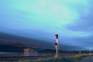
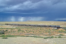
So, after taking exit 202, we drove a few hundred feet on old US-6 when a dirt road turn north off the highway toward the tracks. We ventured up this road and soon found ourselves running parallel to the tracks. We headed east until we came almost back to the bridge where I-70 runs over the tracks (except now we were on the level of the tracks, no above them!). We looked to the right and saw a few hills. Upon reaching the top of the hill, we had a nice view of the east switch of Whitehouse and a bridge just east of the siding for water drainage. There were still no trains around, and there was a major storm cell to the northwest, pouring rain on the horizon and providing occasional lightning for our entertainment.
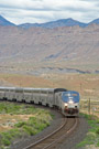
Whitehouse had a string of empty coal hoppers tied down on it (as did Utaline, Floy, and Sphinx), so we knew that no meets would be happening at this siding. We heard that the local had taken the siding at Cisco and the Denver-Stockton had taken the siding at Westwater, but that still didn't tell us how close Amtrak was. About five minutes later, we heard the engineer on Amtrak telling the conductor "we have a lot of Antelope off to our right, if you want to let the passengers know". We have quickly learned that if you can pick up the trains side of a conversation over the scanner, then the train is close! Sure enough, another two minutes and Amtrak was peaking out from behind the string of hoppers at Whitehouse. The storm was still nice and dark in the background, making for a great backdrop for the picture. We took several pictures and noted that the Zephyr had two "Pepsi Cans" (Express Freight box cars) and a private car (the Scottish Thistle) on the end.
After Amtrak had passed out of view to the southeast, we headed back to the truck. Once we were both inside, we reviewed our pictures. After reaching the fourth picture I had shot, I yelled "holy $&^@, check this out!" By absolute pure luck, I manage to capture a lightning bolt hitting the ground behind Amtrak, directly in the middle of the train. It was so fast that I didn't even realize I had captured the bolt when I took the picture.
We started heading back for old US-6 when I noticed that the block signal at east Whitehouse was green. All the mainline signals in the desert are approach lit (meaning the signal is turned off and dark unless there is a train in the block approaching the signal). Thus, we knew the local (being very light with only six cars on the trip west) was already out of Cisco and closing on our position. We both setup for a shot using the drainage bridge. (Webmaster's Note: Anytime you go chasing in the desert, make sure that you have the highest shutter speed you can. An absolute bare minimum of 1/180 if you are shooting from a distance, and a minimum of 1/250 if you are shooting relatively close to the tracks. Anything less and you will likely get some blurring on the train as they move so fast!) The local shot right past us and continued on without a care in the world.
Once we got back to old US-6, we turned west; directly into the storm we had been so happy about moments ago. Before reaching the storm, we noticed that we could actually see blue sky on the far side. This was good news! It meant that the storm cell was not that long. The rain picked up around Sagers and remained heavy until we reached Thompson. Then, we passed out of the storm and were soon under blue skies again. Looking behind us revealed deep blue clouds now in the eastern sky with some sunlight coming down on the wet desert floor.
By the time we reached Brendel, the Potash Local was already halfway done with its switching moves. There is a stub track off of the siding where tank cars carrying fuel are spotted for trucks that come in to fill up for gas stations in the area. We arrived in time to watch the crew complete the switching moves with the tank cars. Once the switching was complete, the train had to pause for an air test. In the meantime, the conductor came over to us and chatted while waiting for the air test to complete. Very friendly guy who informed us that the local would back down the siding and enter the main at the east end of Brendel, and then proceed down the main to the switch that leads to the Potash branch.
After the air test was complete, the train backed down the siding and onto the main. We had to decided if we were going to head down toward Potash, or wait for the Denver-Stockton to show up and chase it west. We heard that the Denver-Stockton was on the approach to Thompson, so we decided to stick with it. As we departed Brendel, we heard the Potash Local receive a track warrant and head south on the Cane Creek Subdivision.
We continued further west to try to find a new perspective for the Denver-Stockton. At Brendel, we were forced to get back on I-70 as old US-6 comes to and end for a short distance (I-70 was built on the original US-6 grade at this location). Another seven miles down the road and we reached exit 173. The road here parallels the tracks again along part of the siding of Floy. Along this stretch of old US-6, you can drive the rest of the way to Green River.
From old US-6, we took one of the dirt roads back towards the tracks west of Floy and east of Solitude. We arrived at one of the several mounds of dirt (one of the mounds we had been at in 2003), and started hiking up the steep pile of dirt. We stopped roughly halfway up and setup for a shot of the Denver-Stockton. While waiting, we heard DS-78 contact the Potash Local again and let them know that, upon arriving at Brendel after switch in Potash, they were to go to Floy and pickup the empty string of hoppers tied down there.
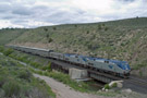
Shortly after we arrived at our spot and caught our breath, the Denver-Stockton came around the corner in the distance. While I snapped several shots of the train approaching from the east, we weren't quite high enough to get the codeline out of the pictures, so I decided not to use any of them. Instead, I used a shot of the train starting through the S-curve just west of our dirt mound. Note the lush foliage along either side of the tracks out in the middle of the desert!
It can be a definite challenge even getting ahead of freight trains out in the desert. A lot of trains can easily make track speed of 60 MPH for a good portion of the desert. So, as we were driving back toward old US-6 from our dirt mound, we were pleased to hear DS-78 contacting maintenance asking them to clear up around the siding of Desert for the Denver-Stockton. They said they would as soon as they could, but that it would take 10 to 15 minutes. that was going to give us the time that we needed!
We went back to I-70 and headed west for the US-6 exit (exit 156) just west of Green River. When you are at exit 156, you are roughly halfway between the sidings of Green River and Sphinx. Our train was already up at Desert (the siding west of Sphinx), so we had a little catching up to do, but fortunately maintenance had not yet cleared up. (Webmaster's Note: Be extremely careful when driving on US-6 between Green River and Price. Make sure you always have your headlights on and be very careful to observe traffic around you. Because US-6 is a two-lane road, people get impatient and try to pass semi's whenever they get the chance, so watch for traffic coming at you in your lane!) Just as we were passing the head end of the Denver-Stockton (which was now at the west end of the siding of Desert), the track maintainer tried to get ahold of DS-78 to release his track and time.
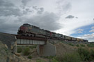
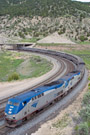
We stopped about two miles past desert, where US-6 crosses over the tracks. For the rest of the trip to Price, the tracks will be on the west side of US-6. We stopped safely on the shoulder of the highway just past the bridge, and hustled back up to get a shot of the train passing underneath us. In the meantime, DS-78 had taken back the track and time and the Denver-Stockton was quickly gaining speed again. Using a shutter speed of 1/500 (and an aperture of F8), I was able to get a very nice shot of the quickly-moving Denver-Stockton as it passed under US-6. The Book Cliffs stood tall in the background.
Once we had shot the Denver-Stockton at Desert, we decided the next best place to try to shoot the train would be somewhere west of Cedar Hill. The train would have to slow down to climb Cedar Hill, so we decided the siding of Cedar would be a good place to head for. When traveling west (geographically north) on US-6, you will pass by the boarded up town of Woodside. The tracks will disappear from view to the west, and the come back into view a few miles up the road. When the tracks come back into view, you will be between Grassy and Cedar. Ahead on the highway, you will see a major hill that you are about to climb. The tracks curve west and charge up Cedar Hill away from you.
Once you have climbed the hill, you will soon see a sign for "Horse Canyon". The road to right (taking you to Horse Canyon) is SR-124 (State Road 124). On the opposite side of US-6 (heading west) at the same intersection is CR-125 (County Road 125). This road will take you down to Cedar. We easily beat the train to Cedar and climbed a cut near the west switch. Just as the train came, however, my camera and my lens decided to momentarily disagree, giving me an "Error 2" message. I had to turn off the camera, remove the lens and then re-attach it and the message was gone. Unfortunately, however, I did not get any descent shots from Cedar.
From Cedar, we tried to follow the tracks west, but quickly realized the road we were on was taking us to a dead end. We turned around and headed back to US-6 as quickly as we could, but by now the damage had been done. We would not be able to catch the Denver-Stockton again before it reached Helper. Fortunately, as we were continuing west on US-6, we heard the Dirt Train contact DS-78. The Dirt Train had completely its switching on the Sunnyside branch for the day and was approaching Mounds. DS-78 said the signal would be setup for them when they go there.
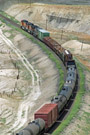
We continued on US-6 until we reached the small town of Wellington. (Webmaster's Note: While you should never exceed the posted speed limit, take particular care to monitor your speed through Wellington as the city police love to setup speed traps, especially on the west end of town!). On the eastern most edge of town, we came to Ridge Road and headed south. Before you reach the tracks, you will see a dirt road with a cattle crossing heading south. It will be a left turn off of Ridge Road if you are coming from US-6. The dirt road is called Famham Road and it will take you back along the east end of Wash and along the tracks all the way to Mounds. We headed along Famham Road out into the desert until we were roughly halfway between Wash and Mounds. We setup on a cut on the (trackwise) south side of the tracks and waiting for the Dirt Train. It showed up about ten minutes later with UP 7060 (an AC6044CW) on the point, and Grande Tunnel Motors 5371 and 5390 behind.
Once we got our shots from this location, it was unlikely that we would catch the Dirt Train again before Helper. The train runs very quickly west, and even after we get off Famham Road and back to asphalt, it is 40 MPH through Wellington. As we passed through Price and headed for Helper, we heard that our luck was holding as a westbound Utah Railway coal train was all set to head west at Utah Railway Junction. Lately, Utah Railway has been leasing power from UP for the head end on coal train. They will, however, cut in five to seven mid-train Helpers for the trip from URJ to Colton. At Colton, the Utah Railway helpers are cut out of the train and return to Martin.
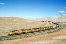
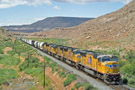
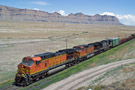
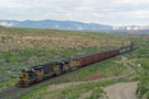
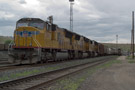
By the time we reached URJ, the coal train had already started west. We caught up to the train just west of Castle Gate and paced the train up the hill. There were five mid-train swing helpers on this day, and it was quite a colorful consist indeed. There were three units painted in the classic gray and red scheme (UR MK50-3 5001, UR SD50 6062, and UR SD50 6064). Then, there was a former ATSF SD45 (rebuilt to an SD40-2 with reporting marks MPEX 5356). And, finally, the east-most unit was UR MK50-3 5005 which is painted in the standard orange Genesee and Wyoming paint scheme, now the parent company of Utah Railway.
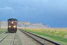
The helpers were cutout at Colton, but there was no good angle for any pictures, so we continued west on US-6 toward Soldier Summit to try to setup for a different shot. Halfway between Colton and Soldier Summit, we found a cut that offers a very nice long-lens shot. Zoomed in all the way at 200mm (the equivalent of 320mm in a 35mm camera), UP 6774 came charging toward us. The train was following the right-hand rule, running west on Main One.
As the train approached Soldier Summit, it slowed down enough to the point that we could again get ahead of it at Soldier Summit. Soldier Summit is the highest point on the former Grande in Utah. It tops out at 7,700 feet above sea level, which is 2,000 feet above Helper. The amazing thing about this is that Helper is only 25 miles to the east of Soldier Summit. This is why there is almost a 2% ruling grade on the east slope of Soldier Summit.
Back in the 1960's and before, Soldier Summit had a small yard, yard offices, and a dispatching station. Indeed at one time, there was even a wye and engines were maintained here at Soldier Summit. Today, however, almost all traces of those days is gone. Aside from the two main tracks and the siding, there are two "yard" tracks and a wye with a short stub at the end. A maintenance shed still stands at the west end of Soldier Summit as well. There is a tall cut near the west end of the "yard" that offers very nice afternoon shots of westbound preparing to descend down into the Spanish Fork Canyon.
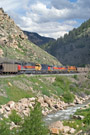
With no other traffic around on Soldier Summit (and the sun starting to get low in the western sky), we decided to continue west to shoot our Utah Railway friend (even though there was no Utah Railway power in site). Although we pulled off a US-6 in a few various spots continuing west, the shots from those locations turned out as simple roster shots and I decided not to include most of them in this report. However, there was one long-lens shot right at the crossover of Narrows that I particularly liked. I hiked along the river a few hundred feet east of the crossover, while Damian stood on the shell of his truck closer to the signals.
After this coal train disappeared into the setting sun, there was no indication of any other trains in the immediate area. With our light quickly fading, we turned around to head back east to Price where we would be spending the night.
There are several hotel choices in Price, but Damian and I typically choose to stay either at the National 9 Inn, or the Holiday Inn. Both hotels are off of exit 240 from US-6. The Holiday Inn is on the (geographic) west side of the highway, and National 9 Inn is on the east side. Both are clean and have always had very good service. We decided to stay at the Holiday Inn this time around, and we were glad that we did. When the lady behind the counter asked why were here, we told her that we were taking pictures of trains in the Price/Helper area. She immediately offered us a 33% discount off the normal rate on our room. We assumed that this was because these hotels primary get people that are just "passing through" and need a place to stay for the night. I think that, since we were here specifically to see trains in Price and Helper, we got a discount.
We had planned to go back to Helper for a few night shots of a very late Amtrak 5, due to arrive shortly after 11pm. However, once we had taken a shower and each laid in our queen size beds for a few minutes, we decided a good nights sleep in a real bed (instead of the bed of the truck) would be best, especially since tomorrow night we would again be in the truck.
DAY 3 - Saturday, June 11, 2005
Saturday morning we felt much more rested after sleeping on a bed with springs, rather than on a bed attached to a frame with shocks! The first thing that crossed our minds when we awoke at 7am was of course: FOOD! We packed up the room and headed for the front desk to check out. While Damian was inside checking out, I heard the Dirt Train (DRGW 5390!) contact DS-78, letting the dispatcher know that they were ready to head east to Mounds. With no opposing traffic, the dispatcher said that the signal would be up for them momentarily.
So much for breakfast! When Damian got back to the truck, we topped of the gas tank and headed east on US-6. We decided the first place to go would be just east of Wash on Famham Road. As the tracks get closer to you when you enter the road, you soon run parallel to them with a tall dirt mound on your left. We parked on the far side of the mound and then hiked about 1/3 of the way up. That offered a nice shot as the Dirt Train rounded the corned out of Wash and headed straight towards us.
After the head end passed, we ran back to the truck. A mile or so down the road from our previous location, Famham Road crosses over the tracks to the (trackwise) south side. Because we had a little bit of a hike back to the truck, the train beat us to the crossing, so we had to wait for the train to pass to continue. However, once we did get across the tracks, it was not too difficult beating the train to Mounds.
Once at Mounds, the road again crosses the tracks and turns into Mound Road. Almost immediately on the other side of the tracks, there is an unnamed dirt road that runs parallel to the tracks past the "yard" at Mounds. If you follow this road, you will come to a small hill that has the tracks immediately on your right and a tall hill on your left. This hill offers a nice view of the S-Curve looking (geographically) west back toward Mounds. We stopped here and hustled up the side of the hill for a couple of shots.
From here, the tracks and the road spill out into an open valley. The tracks have a relatively straight shot to Banning from here, but such is not the case for the road! The unnamed dirt road that we were on leads back to Mound Road. Upon reaching Mound Road, we turned right and headed under the tracks. However, right below the bridge where the tracks cross the road, there was a nice river running across the road. Now, we're not talking Colorado River or anything like that, but it was a good eight feet wide and probably at least ten inches deep. Damian decided that, with enough speed, it would be fine. We hit the water clippin' along, and made it through without a problem. I would not recommend crossing this particular river (okay, I guess creek is more appropriate) unless you have a 4x4 and know what you are doing!
Once on the other side of the tracks, the road climbs to the top of a plateau. The road has again changed names and is now Drill Road. This road took us all the way back to US-6 out in the desert. Fortunately, the Dirt Train doesn't get much above 15 MPH on its trip from Mounds to Sunnyside, Upon reaching US-6, we turned north and went about a mile to Sunnyside Junction. Here, we took a right on SH-123 heading directly for the Book Cliffs. This road curves around and the runs parallel to the tracks for the rest of the trip to the landfill.
About a mile east of the landfill, there is a nice cut that is easily accessible. The south side of the cut is typically the side shot from as that is the side the sun is on, although on cloudy days, either side of the cut would work. Once the train had passed us, we drove a little bit further down toward the landfill, but there are several polls and cars and foliage that obstruct most of the shots. We decided it was time to head back to Price for some breakfast.
On the drive back, we heard that Amtrak was running about six hours late and was still in the Provo / Spanish Fork area, so we knew we had some time! On the drive back to Price on US-6, we started wondering what would become of the Sunnyside Branch once the Dirt Train stops running later this summer. A new landfill is being constructed northwest of Salt Lake City, and trash will be trucked there from Utah largest city, rather than taken by train over Soldier Summit. Thus, the Dirt Train will run no more once trash starts moving to the new fill. The future of the Sunnyside Branch is not the only thing that may be in jeopardy either. Once the Dirt Train stops, there may be nothing to justify keeping the Grande Tunnel Motors in Helper! They may soon be split up and go their separate ways.
We decided that the golden arches were calling to us for breakfast, so we took the US-6 Business Loop exit (exit 246) into Price to find a McDonalds. While eating breakfast, we kept our ears to the scanner to see if anything was destined to head our direction. We finally heard about an eastbound coal load that was coming down off of Soldier Summit. DS-78 was informing the train that they would be entering the upper yard in Helper (yard track 12) so that the DPU unit on the end of their train could be removed. Once that was completed, the train would continue on the CV Spur for loading.
We finished up breakfast and headed back to Helper to see what we could see. We drove down to East Helper Crossover and made our way up the hill above the entrance to the upper yard at Helper. While we were waiting, the rain would very lightly start to fall from time to time, but it wasn't until the train was actually on the move that the rain decided to go ahead and start coming down relatively hard! We got our shots of the train entering Main One at East Helper Crossover, and then covered the cameras and headed back to the truck.
Since we knew that Amtrak would be on its way, and we knew that the coal train leaving was only going to CV Spur, we decided to head west up Solider Summit again to try to find something else. If nothing else came along, we could count on Amtrak for something to chase back out into the desert. It was our intention to camp out in the desert once again.
We made it to Gilluly and still had not seen Amtrak, so we setup for a shot of Amtrak coming through the 180 degree curve where the track pass under US-6. This is a nice shot where, from the outside of the curve, you have Main One (closest to you), the center siding, and Main Two. Although we continually heard maintainers clearing up their track and time for Amtrak, we still sat for close to 30 minutes waiting for the Zephyr to arrive.
Once it did, it was worth the wait! Not only was lighting good (albeit the sky was overcast), but Amtrak was actually running the "wrong way" on Main One, so the train was on the track closest to us. While we were at Soldier Summit, UP had a work train out and about that was in the process of dropping new tie plates along the main track. It looks like UP might be preparing for a bit of a maintenance blitz (new ties, rail, etc?) on Soldier Summit. That is always a good sign, to see UP investing money in the former Grande.
Going over Soldier Summit, Amtrak is not particularly hard to catch most of the time. Between Soldier Summit and Colton, the train can easily reach 60 MPH, but in the Narrows and Gilluly area, it is restricted to 30 to 40 MPH. Amtrak crossed back over to the "proper" track at Colton, now running east on Main Two. (Webmaster's Note: Any reference here to the "proper" track or the "right-hand rule" on Soldier Summit, is nothing more than a standard of operating. There is no hard-and-fast rule about using the right-hand track when operating because Soldier Summit is entirely CTC. This means that DS-78 can run trains on whichever track he or she sees fit at the time. However, when conditions are perfect, there are no slow orders or maintenance, you will typically see trains following the right hand rule on Soldier Summit.)
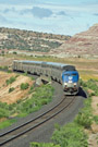
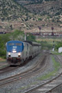
We were able to catch up with Amtrak again at the US-6 overpass between Colton and Kyune. I particularly like this spot for eastbounds as lighting is typically good and you can climb up the embankment under the bridge to get some elevation above the trains. Amtrak on this particular day had a typical consist of two P42DC's for power, one baggage car, one transition sleeper, three coaches, one sightseer, one diner, and two sleepers.
Neither Damian nor myself have ever taken any pictures at West Helper Crossover, and that location stuck out in my mind from a Pentrex video may in 1987 on the Rio Grande. I recall seeing rails on the mountain in the background from there, and later learned that is the Utah Railway's yard at Martin. In addition, the signal bridge at West Helper is a classic D&RGW bridge that will no doubt be replaced by UP sooner or later. When Amtrak passed by, the Zephyr was still on Main Two, which made sense as the train was preparing for a station stop at Helper.
We followed Amtrak into Helper where the Zephyr made its (extremely late) station stop. There were a surprising large number of passengers waiting to board at Helper. That is somewhat unusual as Helper is typically a quick whistle stop without much exchange in passengers. A few passengers did step off the train to have a quick smoke, or just to stretch their legs. Even without any passengers coming on or getting off in Helper, there is still a few minutes stop because Helper is a crew change point for Amtrak. The new crew will take the train across the desert to Grand Junction.
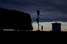
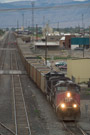
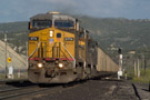
While Amtrak was busy doing its thing with passengers and crew, Damian and I stopped to grab a few shots of the MNYRO-09, which was stopped (with three SD70M's looking nice) for a crew change as well. We left Helper (for the last time on this trip) ahead of Amtrak, knowing that it would be able to move much faster through Helper, Price, and Wellington then we would be able to.
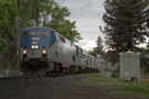
The west switch of Price has always intrigued me because it appears to be sitting in the middle of a park! There are trees all around, and grass comes right up to the switch and the ballast all around. So, even though the lighting was not perfect, we setup for a shot there. Amtrak was very stealthy too! It made very little noise and was moving very quickly when it came up to the signal.
After Amtrak clipped past us, we knew there was no chance of catching them again until somewhere in the desert. We decided to shoot for the Grassy - Woodside - Vista area. As it turned out, we were able to catch the train by Cedar, and get well ahead of it as Amtrak had slow down and wind its way down Cedar Hill, while we just decided straight down the hill on US-6. Unfortunately, though, we were stuck behind a very slow semi, so we couldn't get setup at Grassy and we headed further east.
In the past, we have pulled into the "town" of Woodside (I use the term "town" loosely, because last time I was there, it was really just a gas station). Well, Woodside has gone downhill as the entire "town" (gas station) is completely blocked off and there is no access from US-6 anymore! Instead, we went another mile down the road and found a small dirt road that led over to a cut next to the tracks. We were able to shoot the Zephyr coming around a curve with the Book Cliffs and US-6 in the background.
This, we knew, would be the last chance to shoot Amtrak before Green River unless there was maintenance or some other such condition that would cause Amtrak to slow down. We got back to US-6 and headed east. As we got to the US-6 overpass above the tracks, we heard Amtrak highball Desert, two miles further east. By the time we reached Desert, Amtrak was at Sphinx! We we got to I-70, Amtrak was just entering the siding at Green River to make its station stop.
Back on a four lane highway with a speed limit of 75 MPH, we opened her up and headed east. We were both very interested in shooting in the Thompson Hill area, as there was great scenery and several curves around there. We took I-70 back to exit 185 (the Thompson Springs exit). Off of this exit is a Shell gas station. Beyond the gas station is what is left of the town of Thompson. Most of the building (including the Thompson Motel) are all boarded up and completely abandoned. There are, however, a few mobile homes with people still living in them.
At SH-128 (just before the tracks), we turned right and headed out of town toward Thompson Hill. About a half mile east of the siding of Thompson, there is a nice S-Curve for eastbounds that has some good hills and the Book Cliffs rising up again in the background. We shot the eastbound Zephyr here, and this was last place we would catch the train. Not bad though...Gilluly to Thompson - a distance of 133 miles.
After Amtrak left, we headed east again (in no hurry) along old US-6 to see if we could find our way to the siding of Sagers and Elba. We successfully found both, and indeed I took pictures of Sagers for the Siding Gallery! I was about to shoot Elba as well, when once again the rain started to fall. (Webmaster's Note: When planning a trip to the desert, make sure you pack at least one or two sweatshirts, a descent jacket, gloves, and a hat. Even if it is June, this is very wise. As we learned, it can still get very cold - into the 40's - even in the first two weeks of June!)
We shot the eastbound Zephyr at Thompson at 3pm. By 7pm, we were starting to get hungry and a little bored. The rain had really made a mess out of the nice soft desert dirt. Everything off of the asphalt was rapidly turning to a nice thick mud. It stuck to the tires and it stuck to our shoes! However, we knew that Amtrak 5 (the westbound Zephyr) was not far off, based on Amtrak's automated train status phone service (1-800-872-7245 or 1-800-USARAIL). So, we went back to Thompson Cut and awaited the arrival of Number 5. Again, it was worth the wait. The rain had really brought out the colors in the desert, and even though it was 8pm, there was still enough light to get a nice, soft shot.
Knowing the Amtrak would have to make a station stop at Green River, we quickly headed back to I-70 to see if we could get ahead of Amtrak west around Desert. As we were getting off on US-6 west of Green River, Amtrak was leaving Green River on a clear signal. We knew that once Amtrak got up to track speed, the Zephyr would actually be gaining on us as they could go close to 80 MPH, and we were stuck going 65 MPH. We got to Desert and got out of the truck. I was getting ready to setup the tripod when I heard "Amtrak 5, highball Desert." I looked up and saw Amtrak right on top of us. Foregoing the tripod, I did my best to take pictures at 1/15 a sec using only my hands. Well, you'll note that none of those pictures are posted on the website here! There is a good reason for that. 1/15 is just a little to long for clear pictures without a tripod.
Not even wanting to try to catch Amtrak again, we decided to call it a day and headed back to Green River to get some much-needed dinner. We stopped at the Arby's on the west side and enjoyed a nice dinner break around 9pm. By the time we were done with dinner, around 10pm, we headed back toward Sagers to pitch camp for the night. Let me tell you, it is not easy to find the correct dirt road in the desert at night when you don't even have the Book Cliffs for reference!
We eventually made it to the west switch of Sagers (parked off railroad property, about 50 feet away) around 11pm, just in time to see an eastbound coal train go flying past. So much for our first night shot opportunity. As luck would have it, that would be our only night shot opportunity (with a train) all night long. Oh well, that was okay. We were going to try to capture a few stars with the silhouette of the signal mast in the foreground. Great thought, except that by the time we got the truck setup and our cameras setup, clouds had moved in and there was not a star to be found in the sky.
After trying (without success) to get some descent shots until 1am, we finally gave in to futility when the rain started again, and called it a night. However, we theorized that the storm by move out by 4am or so, and we set an alarm accordingly. Three hours later, the alarm went off and we woke up to storm skies and light rain. We gave up on our night shots for this trip, and set an alarm for 6am, another two hours of sleep.
DAY 4 - Sunday, June 12, 2005
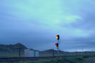
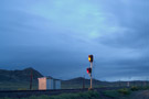
The division point between Day 3 and Day 4 is very fuzzy in my mind. Although I had set an alarm for 6am, my sleep was disturbed around 5:10am by some scanner chatter. I was half awake and planning on turning the volume down, when I heard "BNSF east, advanced approach Sagers." I shot straight up! Even though I didn't catch the number, I heard "east" and "Sagers", and I knew we would not have much time. I looked out the bed of the truck and the signal at West Sagers was proudly displaying an approach signal, yellow over red.
I kicked the tail gate open, grabbed Damian's leg, and told him to get the heck up! We had smartly left our tripods setup outside the night (well, a few hours) before, and covered them with plastic bags to keep the heads from getting wet. This was a very smart idea as we were both able to get our cameras setup (the rain had stopped) and get a few timed shots of the Stockton-Denver flying by, even though it the sky was now rapidly getting lighter.
The head end flew past us and I was able to get a timed shot that showed the yellow signal dropping to red, so in the picture is appears as though the signal is displaying a yellow and red indication simultaneously. As the train slowed (because there was a red signal at the east end of Sagers), we grabbed a few more shots of the train.
The Stockton-Denver contacted DS-78 to ask if they would be meeting a westbound here at Sagers, hence the yellow signal. DS-78 said no, that CTC was having a lot of problem after the long, wet night. The train would have to be flagged past the signal at the east end of the siding. DS-78 did, however, say that they would be meeting a westbound MNYRO at Elba, the next siding to the east.
Damian and I quickly broke down our campsite and started thinking about some possible timed shots that we could do when the MNYRO arrived. That, however, did not work out quite like we had hoped. Because both trains were being flagged past red signals (meaning they were restricted to 10 MPH until the next non-red signal), and because both trains had to hand-operate the switches, it took a little while for the MNYRO to show up.
It was after 6am by the time the train pulled up to the east switch of Sagers (which was red, of course). However, I noticed that the clouds were gone from the western sky. So, even though there was zero direct sunlight, the western sky was offering shutter speeds of at least 1/250 of a second. This would make for a great silhouette shot, and I was able to get two. In both of them, the conductor from the MNYRO-10 was on the ground. He had to put the switch in hand-throw until the lead unit was in the OS, then the switch could be put back in power and the conductor could reboard the train.
The wet weather really caused havoc with the CTC. The MNYRO had to be flagged out of Elba, into Sagers, and out of Sagers, and into Thompson. The intermediates between Sagers and Thompson were not red, however. The first intermediate was clear, and the conductor came over the radio, sounded a little excited, and said "UP 4177 west, back on a clear". However, the next signal was displaying a yellow, meaning the east end of Thompson was red! This time, the conductor sounded flat out annoyed when he said "UP 4177 west, approach Thompson".
This was good for us, because Damian and I had time to climb a dirt mound just east of the east switch of Thompson. This hill is on the other side of the tracks from old US-6 just east of town. From this hill, there is a wonderful view of the S-Curve come over Thompson Hill. The MNYRO was just the perfect length so that the lead unit and the last car of the train (and everything in between) could be captured.
By now, it was almost 8am. While the sun was getting high in the sky, it was still obscured by clouds. That would change, however, by the time we reached Green River. We shot down old US-6 to Brendel and back on I-70. Although the MNYRO didn't have to be flagged out of Thompson, there was a track indication on the main at Brendel, so the train had to run through the siding.
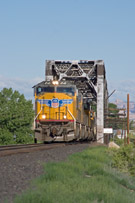
We didn't really setup for a shot at Green River, because we had thought we heard that there was an eastbound coming ahead of Amtrak. We went ahead and got some quick breakfast in Green River (quick = Pop Tarts and Coffee) and headed back to the tracks. We wanted to get a shot of the class American Bridge Company trestle that takes the tracks across the Green River. The trestle was built in 1931 and still stands today. We found that 1170 East Street (just west of the Comfort Inn on the east side of town) is the way to get there. Take that to Elgin Avenue and turn right (west). Elgin Avenue will take you to 700 East Street, and that will get you to the tracks. You then have a nice long lens shot to the west (perfect in morning light) for an oncoming eastbound.
About 15 minutes after getting there, we heard UP 4945 east highball Green River. This was good news as this was the MRONY-11 heading east. With all the SD70M's that UP is running on these manifests now, I'm very happy when I can catch one of these trains. The SD70M has become one of my favorite engines, right next to the SD40-2 (and all variation, read: SD40T-2). After a good shot of the train coming across the bridge, it was again back toward Thompson. This was our last time in Green River for this trip as we knew it was time to start heading home.
We were able to go quite a bit faster than the train, because it was heading uphill. We stopped just east off Brendel, off of old US-6 and found a nice morning shot in the meadow. The power on the train could not have been much better. There were four Phase-II SD70M's, all with flags. The fifth unit was a (rather rare) B40-8, but it was running DIC (Dead In Consist).
There was one more shot in particular that I wanted to try in Thompson, so we paced the train along old US-6 and the way back to town. The shot was again on the opposite side of the tracks, up the hill looking back west toward town. Turned out to be worth the hike as the lighting was perfect and the sky could not have been better lit for an eastbound.
By now it was just past 10am, and we knew we needed to be back in Grand Junction around 12:30pm to make it home by 4:30pm or 5pm (the promised time to our wives). We were also starting to run short on flash card space, so we skipped ahead a bit to the western extreme of Ruby Canyon. We took I-70 east from Thompson to exit 225, the Westwater exit.
The road here is very well maintained and used by rafting companies to pick up rafters that came through Ruby Canyon from upstream. The road is a few miles long, but takes you right to the tracks (as well as the very full Colorado River). Above 200 feet west of the west switch of Westwater is a nice outcropping of rocks. From atop these rocks, there is a nice shot for eastbounds on the approach to Ruby Canyon.
Earlier we had heard that Amtrak 6 was running close to on time, so we were not surprised to hear that the MRONY took the siding at Agate to let Amtrak 6 pass. So, it was the eastbound Zephyr that we caught on the approach to Ruby Canyon.
That worked out well anyway, as we headed back to I-70 to try to find a spot on the eastern extreme of the canyon to shoot the MRONY. We found a spot less than a mile east of Ruby Tunnel, where the tracks pass underneath the I-70 overpass. After a 20 minute wait, the MRONY came out of the canyon with a straight shot into Grand Junction.
This would be the last place we grab any pictures for the trip. It was now 12:15pm and time to head home. After the excitement of the chase was over, our exhaustion really set in. On roughly 3 1/2 hours of sleep, we had run all around the desert in the past seven hours that Sunday morning! Damian was okay driving, but I had nothing to do, and slept off and on for the trip home.
Although it was now clear in Grand Junction, the weather from the previous day had may it to the divide and it was SNOWING very hard on Vail Pass and on the approach to the Eisenhower Tunnel. We're talking white out conditions for a good portion of the drive. Fortunately, it was not sticking to the interstate.
We got home safe and sound shortly before 5pm. The end to another memorable trip to Utah. A trip like none in the past, where we learned more about Utah dirt and mud then we ever wanted to know.
I hope you enjoyed this lengthy report and the pictures included therein. If you have any questions, or just a comment about this report, please feel free to Click Here to send a comment to the Webmaster (Kevin). Your comments are always appreciated!