Train Logs
Summer Trip 2015 Montana Rail Link and Powder River Basin
All pictures on this page can be clicked to see a larger (1050x700) image.
Please note that the pictures and text on this page will display differently in different browsers, based on your own computer's settings.
Starting in 1999, I have tried to take a couple days (usually 3-5) each summer to go on a train photography road trip. That didn't work out in 2013 or 2014 as there was just too much going on at home over the summer. However, the stars aligned in 2015 and I had four days in August. After giving serious thought to taking (another) trip to Utah and Soldier Summit, I changed my mind and decided it was time to head somewhere new. I love Soldier Summit, but I've always been interested in checking out Montana Rail Link. So, the decision was made! The trip would cover as much of the eastern side of MRL as possible. Essentially, Laurel to Helena.
I invited my dad to come along with me for this trip. It is thanks to him that I have the passion for trains and photography that I have. I very clearly remember train chasing with him all the time when I was a kid. I remember a few (single day) trips down the Joint Line. Some of them met with some challenges. On one trip, the battery in his motorcycle dies in Colorado Springs. So it was a walk over to the mall where we got a new one from Sears. We were hoping that this journey would not include any problems!
DAY 1 (Travel Day to Laurel) - Thursday, August 13, 2015
Thursday was going a devoted travel day. We wanted to try to get to Laurel (essentially the east end of the MRL) as early as possible to hopefully have some light in the evening. We left the Denver area at 9:00am and headed north on I-25. We passed by multiple trains on UP's Overland Route in Cheyenne, saw a BNSF manifest at Chugwater, an empty at Wheatland, and several trains along the Canyon Sudivision north of Wendover. However, we didn't stop for any of them.
This was my first time ever going to Montana. I'm fairly well traveled in the United States. Prior to this trip, there were only 13 states I hadn't been to. Montana was one of them. Around 2:30pm, we reached I-90 and left I-25 behind. Another hour later and we were crossing the Wyoming/Montana state line. We finally reached Billings (about nine miles east of Laurel) right around rush hour. Fortunately, the rush hour traffic even in Billings (most populous city in Montana) is far less severe than in Denver. We got our first glimpse of Laurel Yard around 5:30pm!
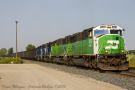
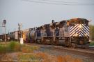
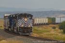
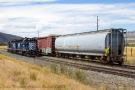
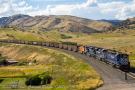
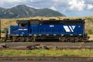
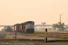
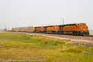
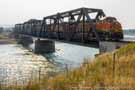
We discovered a (somewhat short) coal load sitting just east of Laurel Yard on Main 1 of MRL's 1st Subdivision. The train had just been recrewed by the 1700 Utility Crew. In addition to a nice pair of MRL SD40-2s, the train had a pair of cascade green SD60Ms as well.
We were rather surprised by just how hot it was in Laurel. The temperature was 96ºF when we arrived. While I wasn't expecting it to be cold, I was thinking that, being so much further north than Colorado, temperatures would be in the 80s at most! After getting some dinner in Billings, we went back to Laurel to see if we might get lucky and find something leaving the yard before the sun set.
The 1700 Utility Crew (the same crew that brought the coal train in earlier) was now working on assembling the "LM". This is the Laurel-Missoula...the only through freight train that MRL runs on their system. MRL connects with BNSF at both the east end and the west end. In fact, the MRL system was once a part of Burlington Northern (and, prior to that, Northern Pacific). In the 1980s, BN decided they didn't need two routes across Montana. The former Great Northern route over Marias Pass had lesser grades, so they got rid of the Northern Pacific route and MRL was born. As conditions changed and rail traffic picked up, it turns out that second route was actually quite useful. So, MRL would take a BN (and now, BNSF) train at one end of the system, leave the existing power on the train, and run it over to the other end of the system. MRL crews operated the train the entire way. A majority of the rail traffic does indeed have BNSF power. However, MRL runs multiple locals and has a lot of customers on the line. So a freight train runs as needed between Laurel and Missoula (and back).
Included on the train was an SDP40R. This was once one of the six SDP40Fs that BN had. I recall seeing these guys on the Beer Run train between Denver and Golden in the 1980s when I was growing up! It was good to see one again. The crew for the "LM" was called at 7pm and got to the train around 7:30pm. After an air check and a rollby from the yard carman, the train was on the move. It entered CTC and Main 2 at West Laurel right at 8pm. There wasn't much time before the sun set, but we gave the best chase we could! The last direct sunlight came at West Laurel. Getting ahead of the train, the last shot came west of Park City, MT at 8:25pm.
We spent Thursday night in a Motel 6 (we were looking to keep costs down!) in Billings. It wasn't a bad hotel...the room was a bit small and it is the first hotel I've ever stayed in that had hard wood floors! But all we needed it for was sleeping, and we accomplished that.
(For all the shots from the first day, click here)
DAY 2 (Laurel to Helena) - Friday, August 14, 2015
The second day started off with us back at Laurel Yard, hoping to see something sent west. We knew that MRL was doing a lot of summer work during the week. They had multiple Form B work zones out on Bozeman Pass and at the siding of Belgrade (which was in the process of being extended to the east). After waiting for about an hour, we decided to hit the road and start making our way toward Livingston. The light wouldn't be great for a westbound anyway!
As we were headed west, we tried to take the I-90 Frontage Road as much as possible. The speed limit (outside of any towns) on the frontage road was 70 MPH. That was a shock to us as you'd never find a two lane road anywhere in Colorado with speeds over 55-60 MPH. We weren't complaining though as it allowed us to make good time. As we were coming by Quebec, we heard "good rollby" ahead from the siding of Greycliff. We stopped off at Quebec and were rewarded with an eastbound BNSF grain train.
We continued west and, after Greycliff, we lost the frontage road and to get on I-90. Of course, as we were approaching Big Timber, we see an eastbound...this time, with MRL power! The "ML" was making its way east. We came to Montana for MRL, so we decided to turn around. We headed back east on I-90 and got ahead of the manifest. We stopped east of Greycliff and got a shot of the SD70ACe-led train. After it passed, it was back to I-90. And, of course, two more headlights! Yep...two more eastbounds came flying by between Greycliff and Big Timber. Stuck on I-90, we had no way to immediately turn around. And since both trains were BNSF, we decided to keep pressing west and not turn around again and try to chase them down.
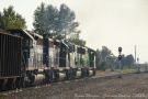
We didn't see any more traffic all the way up and over Bozeman Pass. Knowing that the Form B work zones were active (and seeing MOW equipment on the main), this didn't come as a surprise. I had been told about MRL's 844 local, which runs out of Logan on weekdays. It is called at 10am. We made it to Logan shortly after 11am and heard the local on the radio. It was switching some tank cars out at a little plant just west of Logan on MRL's 5th Subdivision. We waited for switching to be completed there and the continued west to Three Forks, MT.
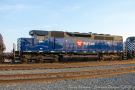
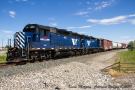
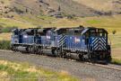
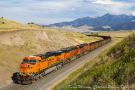
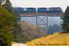
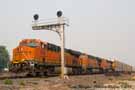
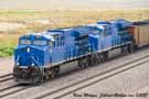
The 5th Subdivision cross under I-90 (and over the Madison River) on east side of Three Forks, so that wound up being a nice location for a shot. For both my dad and myself, the power on the local was particularly special. A pair of GP35s (MRL 403 and MRL 405) worked the local. Why is that so special? Because, like all of MRL's power (save for their SD70ACes), their power was acquired from other railroads; "hand-me-down" power, if you will. Both these hand-me-downs came from Rio Grande! MRL 403 was originally DRGW 3039 and MRL 405 was originaly DRGW 3047. My dad managed to get pictures of nearly every unit on Rio Grande's roster in the late 1970s and early 1980s. No doubt these units are no exception.
Switch at Imerys Talc America plant in Three Forks took close to an hour. The local had to speak with someone at the plant to confirm which cars needed to be switched. After switching was completed, the local continued west toward its final destination on the 5th Sub for the day: Sappington. With a 40 MPH max speed on the 5th Sub, the local had no problem beating us there. There isn't exactly a direct route to Sappington, and we wandered around a bit trying to find our way there. We did get there in time for a few more pictures.
At this point, it was 1:30pm and we were getting excited to see some action on Bozeman Pass. Since it was Friday, we were hopefully that the work zones might clear up a little bit early and we decided we should be in Livingston (the eastern starting point, if you will, for Bozeman) by 3:30pm. We departed Sappington, made our way back to I-90, and started heading east. As we were headed up the west side of Bozeman, we started hearing the MRL dispatcher calling trains to indicate the Form B work zones were now void! Great news! Trains were going to start rolling.
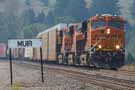
First up was a loaded grain train, climbing up the east side of the pass. We stopped off at the east switch of Muir and waited for the slow-moving train to appear. From Muir, it was up and over the pass to the east portal of Bozeman Tunnel. The east portal is fairly accessible without trespassing. The tunnel itself is 3,015 feet long and the pass is 5,702 feet in elevation. The grain train popped out of the tunnel and started rolling down the western slope. The dispatcher also informed the helpers that there were two more westbounds in Livingston that would need their help. Helpers you say? Did I forget to mention that MRL uses manned helpers on heavy trains west out of Livingston? The helpers shove up to the top of the hill, and then cut off an Muir (without the train even having to stop), and then run east again back to Livingston. It is (roughly) a 22 mile round trip for the helpers.
We left the grain train and headed back east to find the helpers as well as the coal train they were going to help next. We passed the helpers as we descended the east slope and stopped off at the grade crossing at O'Rea Creek Road. Much to our surprise, the SDP40R that we had seen on the "LM" the prior evening (MRL 290) was leading the helper set down the hill. Seems it must have been set out in Livingston overnight.
The helpers made it back down to Livingston and rolled down the siding. A westbound BNSF coal train was sitting on the mainline, all set to head west once the helpers were on the tail end. We found a place to park on Front Street and walked over to the grade crossing to get a few pictures. Then, it was back to the car and off to the west. We wanted to make sure we'd have time to set up for some shots.
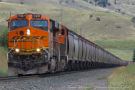
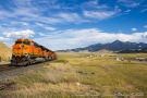
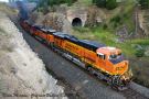
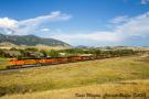
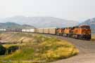
We couldn't have asked for better weather and the lighting for a westbound coming up the hill was perfect. We found a couple of places west of Livingston that offer a great view of not only the train, but of 9,295-foot-tall Livingston Peak! Even though the train was orange and not blue, I have to admit that the pictures from this chase up Bozeman Pass wound up being my favorite pictures of the entire trip!
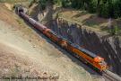
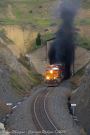
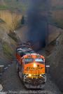
It took the train about an hour to make the 11 mile trip up to the summit from Livingston. Even with the added power, it still a lot of work taking a 17,000 ton coal train up the 1.8% grade! Knowing we had a little bit of time, we hiked in a bit for some different angles on the west portal of Bozeman Tunnel. As the coal train emerged, we got both train and exhaust! A lot of exhaust! Being caught in Bozeman Tunnel with a heavy westbound would be a good way to ruin your day. This is a good time to mention, for those of you not familiar with Bozeman Pass, about the second tunnel. More specifically, the original tunnel. When the Northern Pacific built over Bozeman Pass in 1882, they built a 3,652-foot-long tunnel. That tunnel remained for the next 59 years. However, in 1945, Northern Pacific built a new (shorter) tunnel next to the original. This is the tunnel still in service to this day. The original tunnel portal is still visible, although fences off and some buried in dirt. Tip: If you ever find yourself in Montana and on Bozeman Pass, stay away from the tunnel! Not only would you be seriously trespassing going in it, but you be taking a major risk and the stability of the tunnel is unclear.
We had original talking about returning to Livingston to shoot the second coal train, but we decided against it. We already had some fantastic shots and the math indicated it would be at least another 90 minutes, meaning 7pm, before the next train would be at the summit. We had reservations at a Super 8 in Helena, so we wanted to continue rolling west.
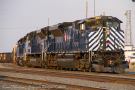
Upon arriving in Bozeman, we found another local (the 841) switching some industries in Bozeman. The train was actually tying up both the main and the siding, preventing our coal train from continuing west. We were not complaining though! We were present with MRL 404. Another GP35. Also, the third and final ex-DRGW GP35 on MRL's roster (ex-DRGW 3043)!
The local finally cleared up and the coal train was able to get through and continued west around 6:30pm. Leaving the local behind to do its work, we stuck with the coal train. We would last see the train just east of Manhattan, MT (population 1,520). Beyond Manhattan and Logan, the train entered Lombard Canyon. By the time it reached the west end of the canyon, it would be too dark to shoot. Getting hungry, we pushed on toward Helena. We didn't see any other trains along the way, so it turned out the shots at Manhattan were it for the day.
(For all the shots from the second day, click here)
DAY 3 (Helena to Gillette) - Saturday, August 15, 2015
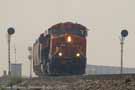
When we woke up Saturday morning, we were surprised by the haze in Helena. It seems that the wind conditions were right overnight to really blow the smoke from the forest fires in to the area. It was so severe in Helena, that objects started to become obscured in smoke after just a couple hundred yards! We decided we still wanted to give Mullan Pass a try, so we went to the yard in Helena to see if anything was pointed west.
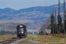
We came across the "LM" in the yard. However, it did not appear that a crew had been called for it, and we had no idea of how long it may be until one was called. So, we decided to just start heading for the pass and see if came across an eastbound. As we neared the Austin Creek Trestle, my dad noticed a quartet of SD70ACes coming around the bend just below Mullan Tunnel. We pulled over and hopped out for a shot of the light helpers coming around the trestle. I wish we could have been a little further up the road, but we didn't want to drive closer and risk missing them come over the trestle.
After the units went over the trestle, we headed back down the dirt road toward Austin. As we were going down, we heard the detector go off. As we came around the bend, we saw an eastbound coal empty descending through the bottom curve at Austin. Ahhh, the one that got away! Knowing that the light helpers were still on their way, we went ahead and set up for a shot at Austin.
We felt we wouldn't have much of a chance at getting the helpers again further east. If you haven't visited Mullan Pass before, Austin Road (which more or less follows the tracks on the east side of the pass) is a dirt road. A dirt road that frequently has rocks or ditches. It is similar to Rollins Pass Road, but arguably not in as good condition. So, we turned around and continued heading west. We wound up driving over the Continental Divide in my wife's little Nissan Versa! It took some time and some caution, but we made it to the west side. Just as we were coming up to Blossburg, another eastbound was approaching too. Had to settle for a bit of a "grab shot" near one leg of the wye.
With "No Trespassing" signs posted, it was quite clear MRL does not want visitors approaching the east portal of Mullan Tunnel. Respecting the signs, we descended the grade west, hoping to come across another eastbound. After waiting for 20 minutes, we decided that we were burning daylight. And the smoke was taking away from a lot of the scenery anyway.
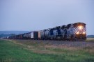
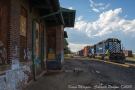
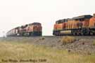
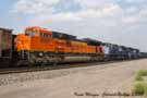
We jointed back up with US-12 and made our way back east to Helena. Upon arriving, we stopped near the east end of the yard to see if perhaps we could chase something back toward Bozeman. We spotted the "ML", with MRL SD70ACe leaders, in the yard. Next to it was the same BNSF manifest we had shot up at Blossburg. A crew van approached from the depot, and we were hopeful it was a crew for the "ML". Alas, the crew climbed on board the BNSF manifest. A few minutes later, they had toned up the dispatcher and received a clear signal to depart the yard. While it wasn't MRL power, at least it was something to chase!
We stopped at a spot at MP 225, roughly halfway between the sidings of Louisville and Winston. At this point, the manifest had slowed down a bit (it had quickly sped up to about 45 MPH after leaving the yard) as it was climbing the west slope of Winston Hill. We jumped ahead a bit and noted an Approach signal (yellow over red) at west Winston. We went down to the east end and thought we could see a westbound climbing Winston Hill from the east. The smoke was so thick, however, we couldn't be sure.
As our eastbound approached, it was clearly slowing to a stop. After stopping on the main, the conductor got out, so we knew it was most likely for a rollby. Sure enough, about two minutes later, the headlight of a westbound loaded grain train appeared. The train was creeping along...couldn't have been more than 10 MPH...as it struggled up the east slope of Winston Hill.
After the meet at Winston, the manifest immediately got a clear signal and departed east. Unfortunately, other than our train, the tracks were incredibly quiet all the way to Livingston! The manifest didn't meet a single train along the way. Well, with one possible exception. It could have met a train somewhere in Lombard Canyon. After we left the tracks at Toston, we took US-287 to Logan and waited there for the train to show up. Hindsight being 20/20, I probably would have tried to get in to Clarkston for a shot, but being brand new to the area, I wasn't sure how long that would take and if we'd be left behind in the canyon!
The train emerged at Logan about an hour after it entered the canyon at Toston. Once we got over Bozeman Pass, we heard the dispatcher tell a westbound coal load at Liviginston that the eastbound manifest was getting close, and to get ready to go up the hill. The manifest ran down the main at Livingston as the coal load was already holding on the siding. As the rear end of the coal train came by, we got our last glimpse of MRL power for our journey.
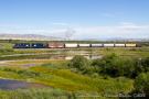
From Livingston, we continued to chase east toward Laurel. Once again, the tracks were extremely quiet. The train did end up meeting a westbound grain train at Quebec, but otherwise, we saw no other trains during the (roughly) 100 mile journey from Livingston to Laurel. As we headed east, we tried to find good spots to get pictures of the manifest. Found a nice overlook of the track and the Yellowstone River off of I-90. It did require turning arond on the Interstate (so we were headed west again), but we didn't have to go far to, once again, turn around and head east.
The saddest part of the trip for us came at the bridge east of Reed Point near MP 51.5. As we drove by on the road to get a shot at the east end of the bridge, we noted a cow standing on the tracks near the west end of the bridge. Despite our honking and yelling at the cow, it just stared at us. We proceeded to the west end of the bridge and waiting. As the train came around the curve to the west, the crew saw the cow and immediately started blowing the horn. Unfortunately, the cow decided it was perfectly happy hanging out where it was and the train struck it. The train was moving at 45 MPH. We (very intentionally) did not get any picture of the unfortuante incident, although we did get a shot of the train at the east end of the bridge. There was no apparent damage (or even blood) on the lead unit. The good news is that it was no doubt very fast for the cow. The crew called in the dispatcher and reported the incident.
We stopped for gas and a restroom break at Park City and, while stopped there, the eastbound came by. We heard the dispatcher tell the crew that they would be holding at Spurling for a bit. It was now 5pm and we needed dinner and to get on the road as we still had a couple hours of driving to Gillette, WY.
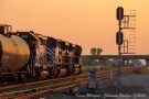
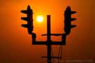
We left the Billings area around 6:30pm. We followed the BNSF Big Horn Subdivision while we still had light, hoping that something would come along. Alas, it was a slow night on the BNSF and we didn't see a single train all the way to Sheridan, WY. Not wanting to come away completely empty handed, we did stop at MP 772.3 (between the sidings of Benteen and Dunmore) and got a shot of the setting sun in a brilliantly orange sky, with an intermediate in the silhouetted in the foreground.
We got in to Gillette just after 9:30pm, found the America's Best Value Inn, and checked in for the night.
(For all the shots from the third day, click here)
DAY 4 (Powder River Basin) - Sunday, August 16, 2015
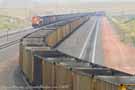
Sunday morning found a bit of haze in the Gillette area. While it was not anywhere near as bad as it had been the previous day in Montana, it was not as clear as we would have otherwise hoped for. We weren't about to let a little haze bug us though, and after checking out of the hotel, we headed for the Powder River Basin. The north 25 miles of the PRB has 5 of the 11 mines. However, those north 25 miles are tough to access too. It is easy enough to get to the tracks, but there really aren't a lot of roads that parallel the tracks. So you have to drive in and the back out and move north or south and then drive back in again.
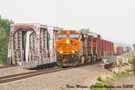
Preferring to avoid the extra driving, we started on Hoadley Road near Coal Creek Junction. It wasn't more than five minutes at the overpass before our first train showed up! It was an eastbound BNSF coal empty, heading for one of the mines further south.
Something worth mentioning at this point is geography vs timetables. Even though the PRB runs north/south geographically, trains run east/west according to the timetable. Trains heading geographically north are westbounds and trains heading geographically south are eastbounds. This dates back to Burlington Northern, the original builder of the line. All of BN's lines ran east/west in the timetable (and in the computer), regardless of their geography. While some ex-BN lines have been changed to be north and south (such as the Front Range Subidvision), some have not.
While I don't know why the PRB hasn't been changed, I can speculate. If the line changes to north/south, the track numbers would have to be reversed. Currently, the eastern-most track (we are talking geographically now) is Main 1. The tracks increase in number moving west. So the western-most track is Main 3 or 4 (depending on how many tracks are there). If the PRB was switched to be north/south, Main 1 would now be the western-most track and the tracks would increase in number moving east. In order to keep things consistent, when their are multiple tracks, the track further to the right when looking west or south is Main 1. The tracks increase in number moving left. So, for the purposes of this article, when I refer to an eastbound, the train is moving south geographically. Westbounds are moving north.
After getting a few shots at Hoadley Road, we continued south a few miles to the next overpass on Lawver Road. We spent about 25 minutes at the Lawver Road overpass. During that time, we saw three trains come through, each one on a different Main!
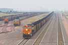
The next stop on the list was the overpass at Reno Junction. This is one of the largest junctions in the PRB. Reno Junction connects the mainline with the Black Thunder Mine loadout and the Black Thunder Mine East loadout. The Black Thunder Mines contribute a lot of traffic to the PRB. In addition to these two mines, you'll also find the Black Thunder Mine West loadout and the South Black Thunder Mine loadout. The west loadout is actually clearly visible from the overpass at Reno Junction. It was constructed just on the west side of the tracks. A conveyor belt carries coal from the Black Thunder Mine several miles to the loadout. This loadout was built in the last 10 years, and allows for more trains to be loaded.
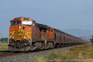
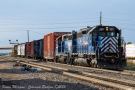
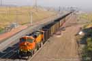
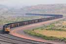
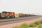
After this eastbound coal load entered Main 1, we hit the road and continued south. We made our way to Converse Junction, which is where the Antelope Mine loadout connects in with the tracks. At this point, there are four main tracks running together in parallel. We caught an eastbound UP coal load on Main 1, which had just left for the North Antelope Mine, and a BNSF empty coming in to one of the inbound tracks for the Antelope Mine.
After that brief stop, it was off to the overpass at the top of Logan Hill. Logan Hill is the steepest part of the Powder River Basin. It has a 1% grade and, while that may not seem like much for mountain railfans used to grades of 2%, it is a lot for trains that don't have mid-train DPUs! The fourth main track was added primarily to ease congestion over Logan Hill.
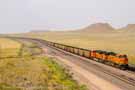
For a little bit of history, the line through the Powder River Basin was originally built by Burlington Northern between 1972 and 1979. By 1985, the single track line was handling 19 million tons of coal per year. Chicago Northwest (financed by Union Pacific) bought 50% of the interest in the line from BN. This resulted in both BN and CNW trains accessing the coal mines. If CNW failed to operate trains, UP would take over based on their investment. In 1994, the single track was resulting in bottlenecks over the line and over the next three years, a second main was added to the entire line. By the year 2000, a third track was added to some of the line to accommodate continuing increases in coal demand. In 2005, the basin handled 325 million tons of coal. In 2006, UP and BNSF invested another $100 million to add a fourth main track to 20 miles (over Logan Hill) of the line. The line is now has the capacity to support 400 million tons of coal annually! At the peak of coal in 2011, the line sees as many as 80 loaded coal trains (meaning 160 total trains) in a 24 hour period! With the current economic climate, which is going more in favor of natural gas and against coal, it will be interesting to see what happens with the Powder River Basin in the coming years.
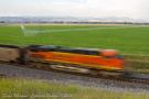
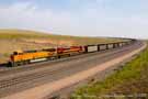
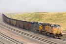
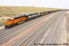
It was now 12:30pm, and we had to start rolling south, stopping briefly for shots as we went. We had to be back in the Denver area by 6pm and, while it is only about a four hour drive, we wanted to be able to stop a few more times if we saw something that caught our eye. And indeed something caught our eye! A few miles south of Bill, we noticed a westbound approaching that clearly had different power. From a distance, the power looked blue. Leasers perhaps? Nope! Turned out that the train was being powered by ET44ACs. These are the Tier 4 emissions compliant engines produced by General Electric. They were being tested in heavy haul coal train service. The train had two on the point and two DPU'd on the rear end.
Unfortunately, WY-59 and the tracks part ways about 30 miles north of the official south end of the Powder River Basin (which is actually the Orin Subdivision). Much like the north 25 miles of the line, the south part is accessible, but harder to move along the line north and south. So, we went to Douglas and got on I-25. From there, we headed south to the small town of Orin (hence the Orin Subdivision) and found Bridger Junction. This is the southern end of the PRB for BNSF. UP leaves the PRB at Shawnee Junction, a bit further north and east. Bridger Junction is where the BNSF Canyon Subdivision (to the south) meets with the Orin Subdivision as well as the Casper Subdivision. The Casper Sub is under track warrants (no signals) and this is the route that BNSF trains use between Denver and Laurel, MT!
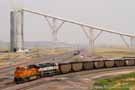
As luck had it, a northbound BNSF manifest was just a few miles away and we waited for him at Bridger. Less than ten years ago, BNSF added a second main track headed south from Bridger Junction. This included the construction of a new bridge of the North Platte River. That bridge, on Main 2, offered up a nice shot.
As the train passed by and entered the Casper Subdivision, our time on this particular journey had run out. It was nearly 3pm and time to hit the road in order to be back home on time. It was a fantastic trip though and one that I know both my dad and I will remember for years to come!
(For all the shots from the fourth and final day, click here)
I hope you enjoyed this lengthy report and the pictures included therein. If you have any questions, or just a comment about this report, please feel free to Click Here to post on the ColoradoRailfan Facebook wall. Your comments are always appreciated!