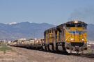
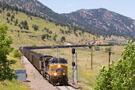
A military train on route from Yermo, CA to Fort Riley, KS heads east on the Limon Subdivision with an SD70ACe on the point. The crew on the train has been on since Speer, WY and is headed for Sable where a relief crew will take the train to Sharon Springs, KS.
Email Questions or Comments to the Webmaster
or add a comment to the picture.
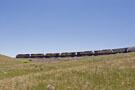
Just east of the east switch of Clay, this eastbound MRONY is entering the upper end of Big ten Curve. In a few minutes, the train will be behind me, heading toward Rocky.
Email Questions or Comments to the Webmaster
or add a comment to the picture.
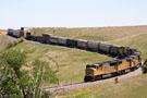
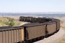
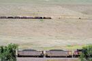
After passing the [wind break] hoppers on Big Ten, this eastbound manifest is continuing east on the main track toward Rocky. This was shot from Jefferson County Open Space between Clay and Rocky.
Email Questions or Comments to the Webmaster
or add a comment to the picture.
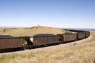
A look toward Little Ten Curve at the west end of the Rocky Siding. The head end power is over a half mile - about 3,000 feet - away from the Winchester & Western hopper visible in the foreground.
Email Questions or Comments to the Webmaster
or add a comment to the picture.
A different perspective of the east switch at Clay as an eastbound coal train leaves the block on an approach diverging signal. After a crew change to Rocky, this coal train will continue east to Chiles, KY.
Email Questions or Comments to the Webmaster
or add a comment to the picture.
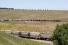
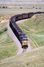
This eastbound coal load heads east out of Clay toward Big Ten Loop. After leaving Clay, the tracks turn east and offer a wonderful view of the Denver-Metro area and plains beyond.
Email Questions or Comments to the Webmaster
or add a comment to the picture.
A wide angle view of Big Ten Curve as seen near the east switch at Clay. The head end power is visible on the left side of the shot, headed west back toward the rest of the train. The hoppers that serve as a wind break on Big Ten are on the other side of the hill with the lone tree on the top.
Email Questions or Comments to the Webmaster
or add a comment to the picture.
A telephoto shot of the head end power on a coal load descending down off of Big Ten Curve toward Rocky. Off in the distance, a car is visible driving south along Colorado Highway 93.
Email Questions or Comments to the Webmaster
or add a comment to the picture.
The head end power on this coal load is almost to MP 18. The end DPU (just coming into view) is right around MP 19.5! Close a mile and a half by rail, but only 3,200 feet as the crow flies. This is how trains have to gain altitude...the long and winding route!
Email Questions or Comments to the Webmaster
or add a comment to the picture.