|
|
|
|
|
Wednesday, September 24, 2025
|
Kevin Morgan
|
|
|
|
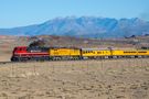
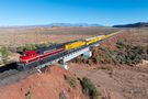
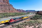
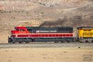
South of Brendel
Grand County, UT
|
203
(Add a Comment)
|
|
|
|
|
Cane Creek (UP)
|
Union Pacific
|
Union Pacific unveiled UP 1616, sporting the paint scheme that honors the 16th US president, Abraham Lincoln, in early 2025. While there was no official word why this unit was painted up, it is widely speculated that it was done in advance of the announcement between Union Pacific and Norfolk Southern to merge. Abraham Lincoln once stated that it was his dream to see a transcontinental railroad that would run from the Pacific to the Atlantic. That certainly seems to be a strong indicator why this unit was created.
Email Questions or Comments to the Webmaster
or add a comment to the picture.
|
|
|
|
|
|
|
|
|
|
Wednesday, September 24, 2025
|
Kevin Morgan
|
|
|
|
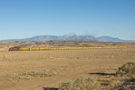
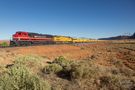
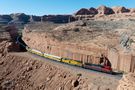
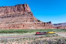
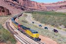
Potash
Grand County, UT
|
302
(Add a Comment)
|
|
|
|
|
Cane Creek (UP)
|
Union Pacific
|
After a five hour run from Rifle, CO, this UP passenger special is finally arriving at its initial destination in Potash, UT. Here, many of the managers (likely the "C-Level" managers such as CEO Jim Vena) will detrain and board the motorcoach that is waiting to take them to Moab. Note the multiple railfans (myself included) parked for some shots of the train. While it is difficult to see details, the gentleman in the dark suit walking alongside the train is one of several Union Pacific special agents that followed the train on the highway, keeping an eye on the right-of-way, ensuring the trains safety.
Email Questions or Comments to the Webmaster
or add a comment to the picture.
|
|
|
|
|
|
|
|
|
|
Wednesday, September 24, 2025
|
Kevin Morgan
|
|
|
|
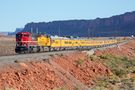
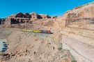
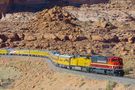
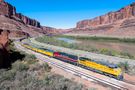
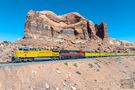
Bootlegger Canyon to Potash
Grand County, UT
|
226
(Add a Comment)
|
|
|
|
|
Cane Creek (UP)
|
Union Pacific
|
UP cleaned every nook and cranny on UP 5898, which is wearing UP's new official paint scheme, for it to lead this passenger special which includes "C-Level" managers from Union Pacific. As you can see, the new paint scheme has removed the wings from the nose, and moved the American flag from the long hood to the nose. While I do not know the reasons for the changes, I would speculate that this new scheme is a little less expensive, with a smaller American flag and no wings on the nose to contend with.
Email Questions or Comments to the Webmaster
or add a comment to the picture.
|
|
|
|
|
|
|