|
|
|
|
|
Sunday, September 22, 2024
|
Kevin Morgan
|
|
|
|
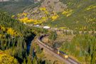
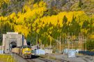
Moffat Tunnel (MP 50.2, 6.2 miles)
Gilpin County, CO
|
364
(Add a Comment)
|
|
|
|
|
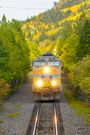
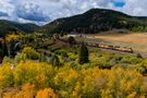
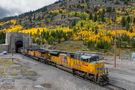
Moffat Tunnel (UP)
|
Union Pacific
|
UP's eastbound MGJNY (Manifest, Grand Junction, CO to North Yard, CO) emerges from the east portal of the Moffat Tunnel under mostly cloudy conditions. 1 hour and 40 minutes earlier, I shot a westbound oil train going into the tunnel here. That time...1 hour and 40 minutes...is how long it took for the oil train to get to Tabernash and for the MGJNY to, in turn, reach East Portal.
Email Questions or Comments to the Webmaster
or add a comment to the picture.
|
|
|
|
|
|
|
|
|
|
Sunday, September 22, 2024
|
Kevin Morgan
|
|
|
|
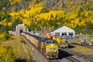
Moffat Tunnel (MP 50.2, 6.2 miles)
Gilpin County, CO
|
338
(Add a Comment)
|
|
|
|
|
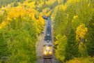
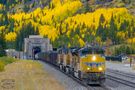
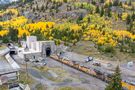
Moffat Tunnel (UP)
|
Union Pacific
|
The crew on this westbound oil empty is prepping for 12 to 15 minutes of darkness as the train will pass beneath the Continental Divide in the 6.2 mile long tunnel. There is actually a lot of infrastructure here at East Portal, built to ventilate the tunnel from exhaust between trains. The tunnel itself (within the mountain) starts several hundred feet back. On a side note, you can see water spilling out of the Moffat Water Tunnel, transported to the east slope from the Winter Park area.
Email Questions or Comments to the Webmaster
or add a comment to the picture.
|
|
|
|
|
|
|
|
|
|
Sunday, September 22, 2024
|
Kevin Morgan
|
|
|
|
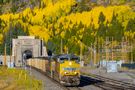
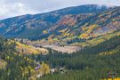
East Portal (5,750 ft)
Gilpin County, CO
|
408
(Add a Comment)
|
|
|
|
|
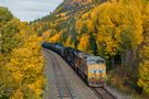
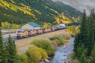
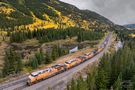
Moffat Tunnel (UP)
|
Union Pacific
|
Five units lead a westbound oil train on the main at East Portal at an altitude of over 9,000 feet (2,700 meters) above sea level, the Moffat is the highest active mainline of any Class 1 Railroad in the United States. About 15 years ago, UP extended Tolland siding, increasing its length from 5,600 feet to over 9,000 feet. Consequently, the siding at East Portal is seemingly never used for meets these days.
Email Questions or Comments to the Webmaster
or add a comment to the picture.
|
|
|
|
|
|
|