|
|
|
|
|
Saturday, May 9, 2026
|
Kevin Morgan
|
|
|
|
CP DS000 (Prospect Junction)
Denver, CO
|
47
(Add a Comment)
|
|
|
|
|
Moffat Tunnel (UP)
|
Amtrak
|
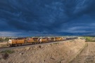
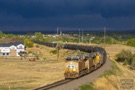
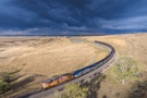
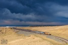
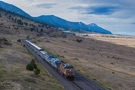
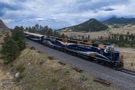
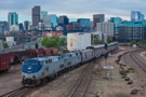
The morning Zephyr is coming to a stop in the OS at Prospect Jct. After the conductor throws a switch behind, the train will make a reverse move across the Buck Lead, into Denver Union Station for its scheduled stop. Prospect Jct a spot where BNSF and Union Pacific meet. In fact, the track the lead units are on is BNSF. The diverging track the train is not on to the right is the very start of UP's Moffat Tunnel Sub.
Email Questions or Comments to the Webmaster
or add a comment to the picture.
|
|
|
|
|
|
|